So a slight detour back to Michigan to show what some wheat near the NCRS looked like. Well there is an AgroLiquid sign along the road with some light wheat and some darker streaks through the field. What's up with that?

This is a field of grower near the NCRS who wanted to try some AgroLiquid nitrogen topdress on his field of winter wheat. He worked with some of the staff there at the NCRS to come up with a program. Well a common N topdress rate around here is 120 lb/A. That's what we use at the NCRS on wheat. So Phil made some strips with the Hagie of 15 gal/A of High NRG-N + 14.5 gal/A of Primagro N + 1 qt/A of Micro 500 + 1 qt/A of MicroLink Manganese. He applied this the morning of April 14 using streamer nozzles. It had been rainy before that, but was dry enough to get it applied. This is what it looked like on the day of application.

The grower was finally able to pull a spinner spreader to apply 200 lb/A of urea (92 lb/A N) on April 24. There has been several inches of rain since. But this is how it looked today on May 3. Which was the first sunny day in some time. If you are tired of guessing, the AgroLiquid was applied where the dark green wheat is and the urea everywhere else.

Good thing Phil stuck in a flag so you could tell where the border is between treatments.. Now we know that we put on more fertilizer than the grower, both rate and cost. And the AgroLiquid was applied 10 days earlier. But that is the comparison vs a grower standard. Prices are always tough to work with, both fertilizer and crop. But I rough guess that the AgroLiquid side will have to yield around 7 more bushels per acre to be equal in cost. The way it looks now I feel pretty good about that.

I asked Stephanie if she would come out and fly our Precision Drone over the field and see how it looked from above. So she did. She's nice that way. Liftoff. You can see one of the strips in the background. Let's see what the drone saw.

It flew at 80 meters (260 feet) and made four passes over the field taking a picture every two seconds. Somehow it stitched it all into one image. This is the RGB image which is pretty much normal vision. Although you can certainly see the green strips, I thought they looked greener in real view.

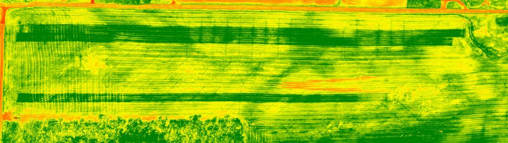
But if it's green-ness that you want to see, then the drone also gives an NDVI image. This is a measurement of green vegetation density. No question about that in this image. So we will follow this through the season and get some yield checks to find out the rest of the story.
On the way to the office, here is the apple orchard that is in blossom now. Did you know that the Apple Blossom is the state flower of Michigan? Well it is. I saluted. And there were also some Robins in there, the state bird. My arm got tired from all of the saluting. It has been plenty rainy lately, but fortunately I didn't see any Brook Trout in the orchard, which is the state fish.

Well the planter and various field equipment is ready to go once it stops raining and dries out. Fortunately we haven't had as much rain or snow as other parts of the country. Crazy spring. But we are still waiting.